Field Officer's Report for June & July 2008
Posted under: journal >> Reports- By: Chaz Morse |
- Aug 01, 2008
- Share
- del.icio.us

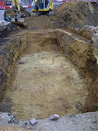
The excavation of Zone 2 was completed on the 11th July. The archaeology in this central area of the site consisted of three main periods of activity, a pattern that corresponded with the excavated results from Zone 1. The latest period of activity was the late post-Medieval housing and associated drainage features, such as soak-aways, which again proved prevalent as intrusive features. In the north-east of the area the construction of the basements and foundation walls for the Victorian housing had cut deeply into the natural gravels. This resulted in the archaeology within the footprint of these structures being heavily truncated. However, such deep basementing only occurred in a small area, and the remainder of Zone 2 presented a well preserved sequence of archaeological activity.
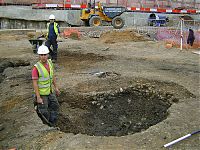
The excavation of one of the soak-aways in the northern half revealed a circular stone structure, cut into the ground at a depth of c.1.8m, that had been truncated on its eastern side by the construction of the soak-away.
This stone-lined pit had an access point on its northern side and so was possibly used for storage, allowing the stored material to be retrieved from its base. Once this feature had been fully excavated a series of Roman pits was revealed. This proved to be a very complex sequence, and had some of our best stratigraphic minds intrigued for a while. Yet when such complexities were resolved and these inter-cutting pits were fully recorded, they were realized to be the tip of the ice-berg when it came to Roman pitting in Zone 2. All these archaeological features had been cut in to the back fill of a much larger Roman quarry pit.
This pit was dug into two-thirds of the area, and its size indicated that the quarrying process was carried out on an industrial scale. This is consistent with the findings from the excavations from the West Tenter Street site (WTN84) in 1984, c. 10 metres to the north of the Prescot Street site. Here the burials and later activity was also found to have been cut into the in-fill of a large Roman quarry pit, demonstrating that quarrying was the primary Roman activity in the area.
In the south of Zone 2, the basements of Georgian housing had survived and was duly recorded. This was found to have been cut to a lesser depth than the Victorian housing to the north, and so the underlying preservation was fairly good. A cluster of early post-Medieval quarry pits were recorded below the basement slabs. They were cut deeply in to the natural gravels, the material that those quarrying were after, and so these large pits had cut away any earlier archaeology that may have been in the area. However to the east of these quarry pits was a number of inhumations and cremations, and these are certain to add valuable information to our knowledge of Roman cemetery practices. To the north of the quarry pits was a large Roman ditch that had been re-cut indicating that it was considered important enough to warrant maintenance for its continuous use. The primary fill of the re-cut ditch was noted to contain a number of reposted cremations and is considered to have significance for the changing use and lay out of the of the East London Roman Cemetery over time.
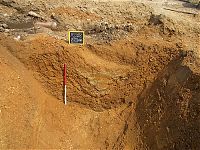
In this southern half of Zone 2, the deepest cut features were found to be dug into the palaeo-channel or perri-glacial-channel that was recorded in Zone 1. However, the channel had had been heavily truncated, particularly by the cluster of Post-Medieval quarry pits, and so its extent was much more limited than that known of in Zone 1.


