How do the archaeologists from L – P : Archaeology know where there is buried archaeology if they can’t see it?
In big cities like London, people have been changing the landscape for thousands of years. In the past few hundred years, London has undergone a transformation from a small compact city with surrounding hamlets and villages, to a vast sprawling urban conglomeration. It is likely that there is archaeology to be found in most areas of the modern city. But how do archaeologists know this?
Every Borough Council in London has to keep records of where archaeological sites or stray finds of ancient objects have been found in the past. This is known as the the Historic Environment Record, and is also known as a ‘Sites and Monuments Record’.
Archaeologists in urban areas first start to find out if the site the developer plans to build on contains archaeology by looking at the HER. This is where the archaeologists working on the Prescot Site found all the information they needed to write a desk based assessment.
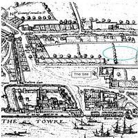
Desk based assessments are written by looking at the evidence for previous archaeology in the area, through local and national databases, archaeological journals, local history books, old maps, Tithe maps, old Ordnance Survey maps, the British Geological Survey (to find out what kind of geology lies beneath any archaeology on site), and any other work that may have been done on site that would indicate that archaeology survives underground.
After the desk based assessment was completed, the archaeologists had to undertake an evaluation – a sort of mini-excavation – to see if the findings form the desk based assessment meant the site had archaeology on it still. In a built up area like East London, it is impossible to use archaeological geophysics techniques to investigate the site that you may see on Time Team.
- By: Lorna Richardson |
- Feb 13, 2008
- Share
